Rainfall Australia
Rainfall inputs, engineering calculators & weather
Projects
Saved on this browserProjects stay on this device. Export a backup before clearing browser data.
01 Location input
Australia-wideSearch, select a result, then Fetch rainfall data.
Powered by Geoapify · © OpenStreetMap contributors
Decimal degrees · latitude first · separated by a comma
ARR · Not fetchedBOM · Not fetched
Location and ARR
Enter coordinates- Latitude / longitude
- —
- ARR river region
- —
- Temporal pattern region
- —
- Initial loss (mm)
- —
- Continuing loss (mm/h)
- —
Climate change factors
- Rainfall multiplier
- —
- Initial loss multiplier
- —
- Continuing loss multiplier
- —
- Temperature change
- —
Fetch ARR data, then select duration and SSP.
Selected-year table values · factors only · source downloads remain unchanged. Duration options follow ARR's published columns.
BOM rainfall lookup
—Fetch BOM to populate the available durations and AEPs.
Source depths are unchanged. Intensity = depth ÷ duration in hours. No climate multiplier is applied.
03 Storm Generator inputs
Three source files, ready for manual import.
Ready to retrieve inputs
Source files retain their original data and formats.
Location preview
Australia-wideLOCATION PREVIEWNo point selected
Click map to select · drag to pan · +/− to zoom
WGS 84 · click to set coordinatesReport map issue
Stormcalc
Hydrology & hydraulicsChoose a category and calculator. Apply values between tools when ready; save or export your project to keep the inputs.
Rational Method
mm/hr
Pre-Development
Post-Development
Chart is for indicative purposes only and may not represent full design conditions. Always validate calculations before reporting.
Dam Volume
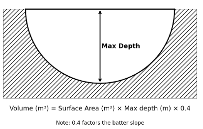
Quick Calc
m
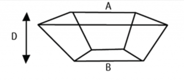
Square Dam
m
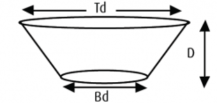
Circular Dam
m
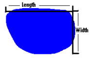
Gully Dam
Manning's Equation
Manning’s roughness reference
| Material | Manning's n |
|---|---|
| Concrete | 0.012 - 0.017 |
| Steel | 0.010 - 0.015 |
| Cast Iron | 0.011 - 0.015 |
| PVC | 0.009 - 0.015 |
| Brick | 0.014 - 0.016 |
| Earthen, straight and uniform | 0.020 - 0.030 |
Weighted runoff coefficient
One surface per line: area (m²), runoff coefficient (0–1). Enter project-specific coefficients.
Pre / post runoff
Orifice discharge
Rectangular weir discharge
Storage drawdown time
Part-full circular pipe
Open channel capacity
Stage–storage and usable volume
One surveyed level / area per line: elevation (m), plan area (m²). First level is the zero-storage datum.
Swinburne OSD — PSD & critical storage
One storage-design storm per line: duration (min), intensity (mm/h). Test a range of durations.
Weather, in plain English
Bureau of MeteorologyDaily outlook, temperatures and rainfall for the week ahead.
Live forecasts are not connected yet. Open BOM for the current outlook, or import a BOM forecast XML file below to read it here.
No forecast loaded. Forecasts are separate from design rainfall inputs.
Reading your forecast
Chance of rain is the forecast likelihood of rain for the day. Rainfall amount is the range supplied by BOM. Missing values are shown as unavailable, not zero.
Forecasts can change. Check the issue time and use BOM for current warnings.